
A high-occupancy-vehicle(HOV) highway(for use by buses, vanpools, carpools and private vehicles with more than two occupants) was also planned as part of the project. It would use a former railroad tunnel, which provides north-south access through Mount Washington[located between the Fort Pitt Tunnel(Penn-Licnoln Parkway West) and the Port Authority's Mount Washington Trolley/Transit Tunnel(used by the "T South" Light Rail Transit System and buses of the South Busway)] and then use a new, to-be-constructed, bridge across the Monongahela River into Downtown Pittsburgh. Originally, the bridge would access the Golden Triangle at the intersection of Fort Pitt Boulevard and Market Street; a new city, riverfront park would be constructed below the bridge, on what is now known as the Monongahela Wharf parking area. However, other bridge locations, including Fort Pitt Boulevard at Stanwix Street and at Grant Street, were also under consideration.
The former railroad tunnel, the Wabash Tunnel, was originally constructed at the beginning of the twentieth century for Jay Gould's Wabash and Pittsburgh Terminal Railroad and later used by the Pittsburgh and West Virginia Railroad. In the 1960s, it was rehabilitated for use in the proposed South Hills "Skybus" rapid transit system, which was never built; it was rehabilitated, again, for use as part of the Wabash HOV Facility.
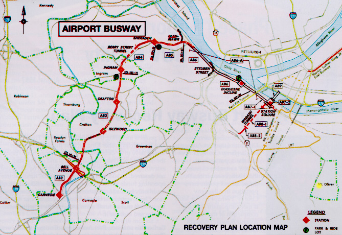
The proposed Wabash HOV Facility would start at the southern end of the Wabash Tunnel[near the intersection of Saw Mill Run Boulevard(PA route 51) and Woodruff Street] and run through the tunnel. It meets the Airport Busway at the north end of the tunnel(across West Carson Street from Station Square) and travels into Downtown Pittsburgh on a combined busway/HOV bridge over the Monongahela River.
In 1997, the Federal Department of Transportation approved a recovery plan, proposed by the Port Authority of Allegheny County, which restricts construction of the Airport Busway to the former railroad right-of-way between West Carson Street, near the Corliss Tunnel, and Carnegie. Preferential treatment for buses[known as Transit System Management(TSM)] on West Carson Street would allow buses transit between the Corliss Tunnel and Downtown Pittsburgh. Airport Busway buses would pass the Lower Station of The Duquesne Incline, with a stop at the Incline.
The Wabash HOV Facility is still part of the project, utilizing the Wabash
Tunnel. However, after exiting the Tunnel, vehicles would use a ramp to
access West Carson Street. From there, the vehicles could continue into
Downtown Pittsburgh, using the Smithfield Street Bridge, or proceed to the
South Side or the West End on Carson Street. Vehicles destined for the
The Duquesne
Incline need only turn left onto West Carson Street, at the end of this
Wabash HOV ramp, and proceed less than a mile to reach the free
parking lot, located across West Carson Street, from the Lower Station of
The
Duquesne Incline.
Quick-Reference Page - Transportation
History of Andrew Carnegie and Carnegie Libraries
Return to History Cover Page
Return to Public Transportation
Return to Directions/Free Parking